Biodiversity patterns can be examined at different scales, ranging from global to local. At the global scale, biodiversity is not evenly distributed, with some regions of the world having much higher levels of biodiversity than others. This variation in biodiversity is influenced by a variety of factors, such as latitude, climate, geology, and history. For example, the tropics are known for their high levels of biodiversity, with rainforests and coral reefs being particularly important ecosystems.
At smaller scales, biodiversity patterns can be influenced by a range of factors, such as topography, soil, water availability, and human activities. For example, mountainous regions tend to have high levels of biodiversity due to the diversity of microclimates and habitats that are found at different elevations. Similarly, wetlands and river systems are often important habitats for a wide range of species.
Global Biodiversity Patterns
At the global scale, biodiversity is not evenly distributed, with some regions of the world having much higher levels of biodiversity than others. This variation in biodiversity is influenced by a variety of factors, such as latitude, climate, geology, and history.
One of the most well-known patterns of global biodiversity is the latitudinal gradient, which describes the trend of decreasing biodiversity from the equator towards the poles. The tropics, particularly rainforests and coral reefs, are known for their high levels of biodiversity, while the poles and deserts have much lower levels. This pattern is thought to be driven by a combination of factors, including climate stability, productivity, and speciation rates.
Another global pattern of biodiversity is the relationship between biodiversity and habitat heterogeneity. Areas with a variety of habitats, such as mountains or river systems, tend to have higher levels of biodiversity than areas with homogenous habitats, such as deserts or grasslands. This pattern is thought to be driven by the availability of a range of ecological niches and the ability of species to adapt to different habitats.
At the global scale, biodiversity patterns can also be influenced by historical factors such as glaciation and continental drift. For example, the separation of South America from Africa allowed for the evolution of unique species such as the platypus and marsupials in Australia.
Regional Biodiversity Patterns
At smaller scales, biodiversity patterns can be influenced by a range of factors, such as topography, soil, water availability, and human activities. In some regions, the influence of these factors can create unique biodiversity patterns.
For example, the Appalachian Mountains in North America are known for their high levels of plant diversity, with over 3,000 species of plants found in the region. This is thought to be driven by the range of ecological niches provided by the diverse topography and soil types in the region.
Similarly, the Mediterranean region is known for its high levels of plant diversity, with over 20,000 plant species found in the region. This is thought to be driven by a combination of factors, including the region’s climate, which has a mild winter and dry summer, as well as the region’s history of human activity, which has led to the development of unique agricultural practices such as terraced farming.
Local Biodiversity Patterns
At the smallest scales, biodiversity patterns can be influenced by microhabitat variations, such as soil moisture, pH, and light levels. These factors can create unique niches for different species, leading to high levels of biodiversity in small areas.
For example, the forest floor is often much more diverse than the canopy of a forest, due to the range of microhabitats created by fallen leaves, logs, and other debris. Similarly, small patches of wetland habitat within a larger landscape can support a diverse range of species adapted to wetland conditions.
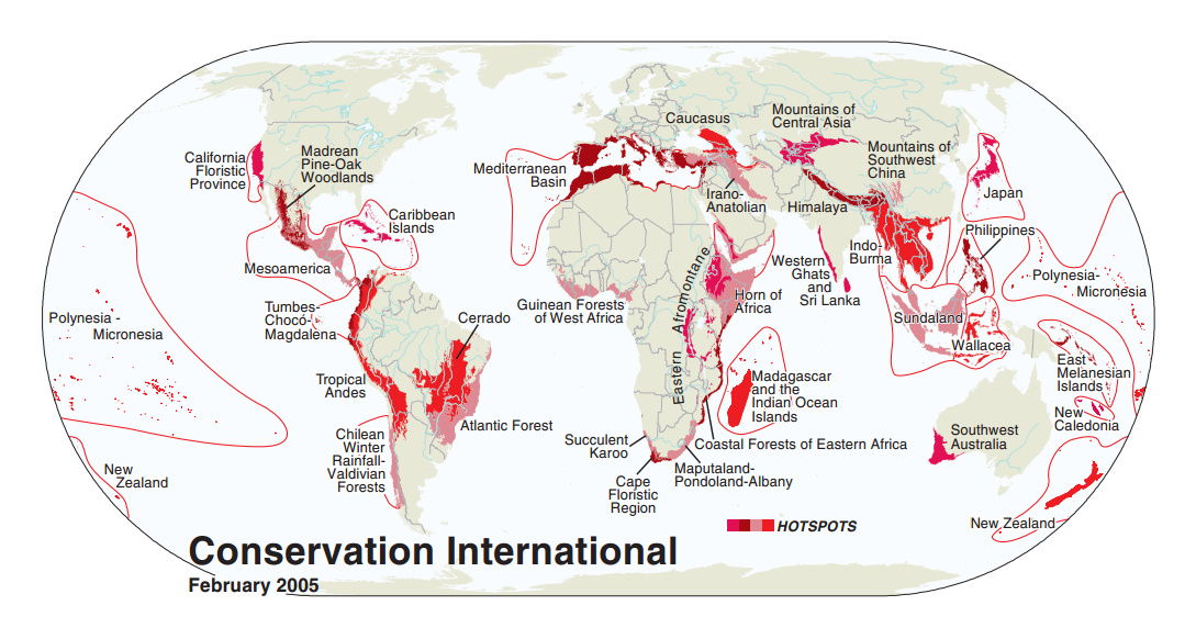
Global Biodiversity Hotspots
Global biodiversity hotspots are areas of the world that are particularly rich in biodiversity but are also under threat from human activities. These areas have been identified as priorities for conservation efforts, as they contain a large proportion of the world’s plant and animal species, many of which are found nowhere else in the world. The concept of biodiversity hotspots was first introduced by Norman Myers in the 1980s, and has since become an important tool for conservation planning.
To be considered a biodiversity hotspot, an area must meet two criteria: it must contain at least 1,500 species of vascular plants (> 0.5% of the world’s total) that are endemic (i.e., found nowhere else in the world), and it must have lost at least 70% of its original habitat. Using these criteria, a total of 36 biodiversity hotspots have been identified around the world, which collectively cover only 2.3% of the Earth’s land surface but contain over half of the world’s plant species and 43% of all bird, mammal, reptile, and amphibian species.
Examples of biodiversity hotspots include the Tropical Andes in South America, which is home to over 45,000 plant species and a variety of unique ecosystems such as cloud forests and high-altitude grasslands, but is also under threat from deforestation, mining, and agricultural expansion. Another example is the Western Ghats in India, which is one of the world’s eight “hottest hotspots” due to its high levels of biodiversity and endemism, but is also threatened by habitat loss, fragmentation, and invasive species.
There are currently 36 recognized biodiversity hotspots. These are Earth’s most biologically rich—yet threatened—terrestrial regions.
To qualify as a biodiversity hotspot, an area must meet two strict criteria:
- Contain at least 1,500 species of vascular plants found nowhere else on Earth (known as “endemic” species).
- Have lost at least 70 percent of its primary native vegetation.
Many of the biodiversity hotspots exceed the two criteria. For example, both the Sundaland Hotspot in Southeast Asia and the Tropical Andes Hotspot in South America have about 15,000 endemic plant species. The loss of vegetation in some hotspots has reached a startling 95 percent.
Following the criteria must for an area to be declared as Biodiversity Hotspot, there are major four biodiversity hotspots in India:
- The Himalayas
- Indo-Burma Region
- The Western Ghats
The Himalayas
Considered the highest in the world, the Himalayas (overall) comprises North-East India, Bhutan, Central and Eastern parts of Nepal. This region (NE Himalayas) holds a record of having 163 endangered species which includes the Wild Asian Water Buffalo, One-horned Rhino; and as many as 10,000 plant species, of which 3160 are endemic. This mountain range covers nearly 750,000 km2.
Indo – Burma Region
The Indo-Burma Region is stretched over a distance of 2,373,000 km². In the last 12 years, 6 large mammal species have been discovered in this region: the Large-antlered Muntjac, the Annamite Muntjac, the Grey-shanked Douc, the Annamite Striped Rabbit, the Leaf Deer, and the Saola.
This hotspot is also known for the endemic freshwater turtle species, most of which are threatened with extinction, due to over-harvesting and extensive habitat loss. There are also 1,300 different bird species, including the threatened White-eared Night-heron, the Grey-crowned Crocias, and the Orange-necked Partridge.
The Western Ghats
The Western Ghats are present along the western edge of peninsular India and covers most of the deciduous forests and rain forests. As per UNESCO, it is home to at least 325 globally threatened flora, fauna, bird, amphibian, reptile and fish species. Originally, the vegetation in this region was spread over 190,000 km2 but has been now reduced to 43,000 km2. The region is also known for the globally threatened flora and fauna represented by 229 plant species, 31 mammal species, 15 bird species, 43 amphibian species, 5 reptile species and 1 fish species. UNESCO mentions that “Of the total 325 globally threatened species in the Western Ghats, 129 are classified as Vulnerable, 145 as Endangered and 51 as Critically Endangered.”
Knowing in detail about the Western Ghats will be helpful for the aspirants for the Geography preparation.